Medium and Longer Hikes in Yellowstone
In another post I described several shorter hikes I've done in Yellowstone, mostly in the range of a couple miles round-trip and shorter. Here are some longer ones.
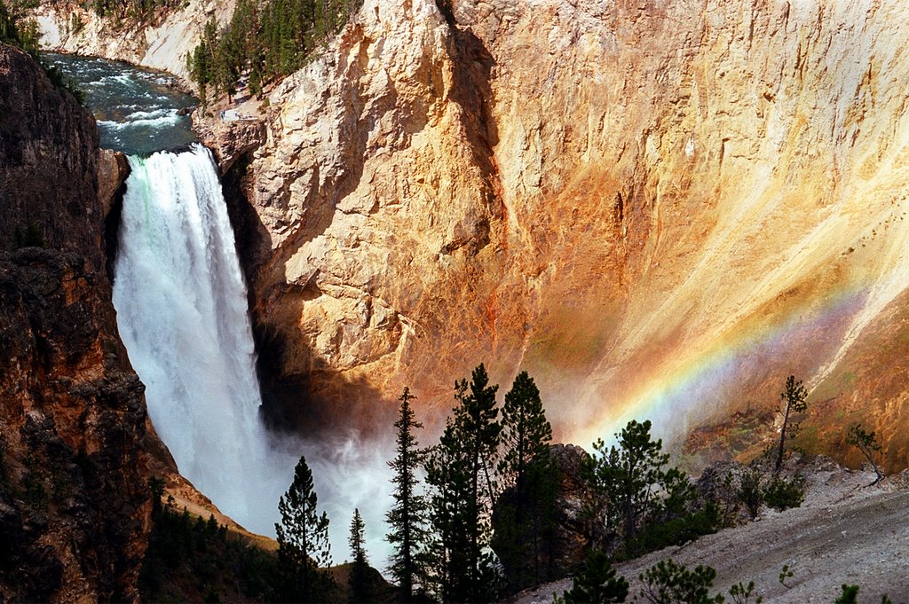
Clear Lake/Lilypad Lake/Artist Point Loop: This hike in the vicinity of the Grand Canyon of the Yellowstone gives as much variety in a relatively short distance as any in the park. You can start at either the Uncle Tom’s trailhead parking area (walk east across the Artist Point road to start the hike) or the Chittenden Bridge parking area (first parking to the right after you turn off the main loop road onto the Artist Point road). I prefer the second option, even though it adds a few tenths of a mile to the overall hike—I like the meadows you walk through to begin. Either way, your first destination is Clear Lake, a nice little lake in the woods with some bubbling action along the shore from thermal activity (nothing dramatic, but interesting to see). From there you shortly reach a small but neat thermal area with some fumaroles, mud pots and such—be careful going through here. Following the thermal area, you come to Lilypad Lake—this is where you should take a left turn to get to the canyon rim (continuing on will eventually take you to Ribbon Lake, which is nice enough but to me wasn’t different enough from the other lakes to justify going several more miles). Reaching the canyon, turn to the left, and again be careful along the rim. This stretch doesn’t gain much elevation, but you’ll do some wandering up and down along the ridges of the canyon—nothing strenuous, but be aware that it isn’t “flat.” Civilization returns at Artist Point, where the most famous view of the canyon (and lots and lots of people) can be found. Continuing on the rim trail will eventually take you back to the Uncle Tom’s trailhead, where you either started or can cross the road to get back to the Chittenden Bridge area. Total distance is in the 3-4 mile range, depending on how exactly you do the hike. Overall, a great introduction to Yellowstone away from the road and the crowds.
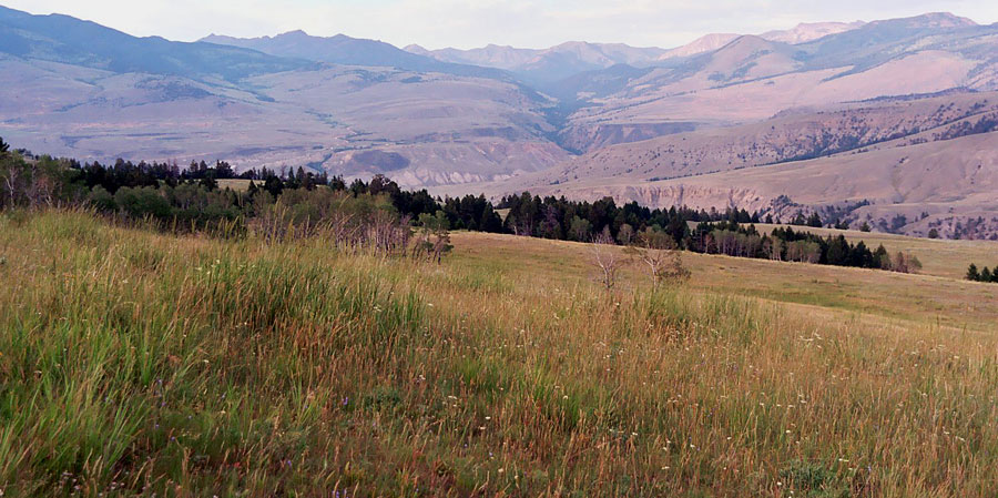
Beaver Ponds: This is about a 5-mile loop starting from Mammoth Hot Springs, next to the Liberty Cap formation. It starts off beside a terrace and then climbs for a mile or so (somewhat more steeply than a couple of guidebooks tend to state) through the trees. Leveling out, you then pass alternately through meadows and stands of aspens and other trees before reaching the first of the ponds. At certain times of year this area is known for the chance to spot a variety of wildlife, but when we did the hike in early August there was (predictably) not much to be seen. You return after passing all of the ponds (4 or 5 all together) on a ridge high above the road that connects the Mammoth complex with the border town of Gardiner. Sections of this trail could be hot and exposed on a warm midday, so consider doing it as an early or late-day hike. Some outstanding panoramic views.
Fairy Falls: There are a couple of different options to do this hike, which can be anywhere from around 4 to 5 miles round-trip depending on which you choose. The exact option we used back in 1993 no longer exists, as it utilized a parking area at the end of a dead-end road that is no longer open to vehicles. Whichever option you choose, try to go with one that passes through the meadows near the Midway Geyser Basin, as this is the most interesting section of the trail—much of the rest of the hike goes through a flat and fairly monotonous section of woods. For this reason it is not one of my “top-flight” hikes, although the falls themselves are very pretty and impressive. I am somewhat in a minority here, though, as I have heard many folks say it is among their favorites. If you choose it and love it, I’ll claim credit for pointing you there, but if you don’t I’ll say I told you so, ha. Personally, if I only had time for one waterfall hike in this general area (not too far from the Old Faithful complex) I would choose Mystic Falls (at Biscuit Basin).
Mount Washburn: This is considered by many to be the single biggest “must-do” hike in Yellowstone. While I wouldn’t necessarily agree with that, the view from the top is impressive, as you can see for literally dozens of miles in all directions. The Grand Canyon of the Yellowstone is laid out to your east, Hayden Valley (and even the Grand Tetons on a haze-free day) are visible to the south, and mountains ring you to the west and north. Plus, this is the one spot where you have a pretty good chance of seeing bighorn sheep. Just be aware that it is a long slog uphill—there are two choices of trailheads, one each on the south and north sides of Dunraven Pass between Canyon and Tower, and both climb well over 1000 feet in 2 and a half to 3 miles. It’s also much cooler at the top, so take that into consideration. There is a lookout station on top that will provide some shelter if the elements take a turn for the worse.
Seven Mile Hole: I can never decide whether I should “officially” recommend this hike or not. On the one hand, the spot it reaches is really cool, and is about the only reasonable way to reach the Yellowstone River within the Grand Canyon. On the other, it is a fairly long hike that mostly passes through non-descript woods, and the final section is an almost scary descent to the river (and the accompanying tromp back UP the hill is a gasser). Still, being on the edge of the rushing river is an undeniable thrill, so figure it out for yourself—just consider yourself warned. If you go, go to the Canyon area and head out on the one-way North Rim drive, taking the side road toward Inspiration Point. Shortly before you reach the point, park at the Glacier Boulder trailhead. The first four miles or so of the trail are through the afore-mentioned woods, with only an occasional glimpse of the canyon. The final mile (the trail is 5 miles each way—the “Seven Mile” part refers to the distance downstream from the Lower Falls) drops 800 feet or so down an uneven path, past a couple of small thermal areas, to the river. Expect to see some hardy fishermen who will look at you funny when they realize you have no fishing equipment.
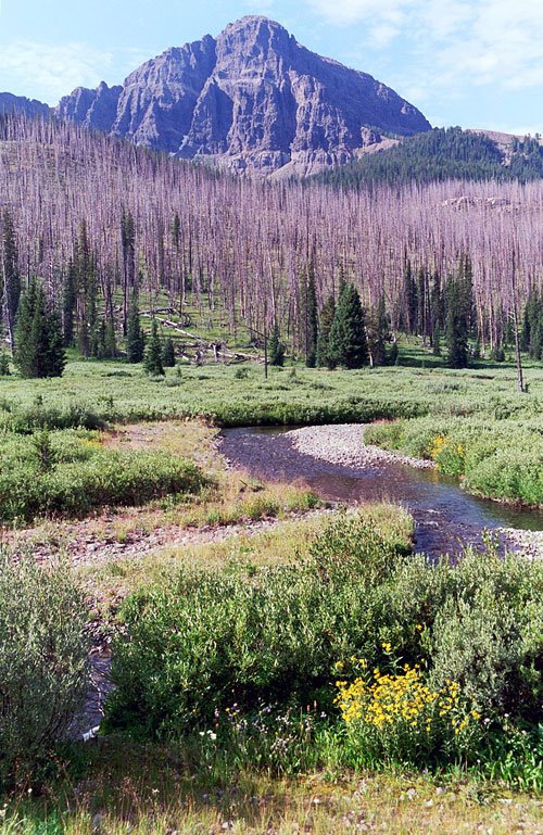
Pebble Creek: This is maybe the single most impressive hike I’ve taken in Yellowstone, at least from a scenery perspective—but it is also the longest and hardest, so don’t believe anyone who tells you it’s an “easy” hike. You start at the Warm Creek trailhead, just inside the Northeast Entrance station, and immediately start up through the trees. Up, up, up and up you go—this is a steep hill, and you’re going up it for a full mile and a half until you reach the top of a ridge and drop down into a valley on the other side. Once to that point, though, the hard work is essentially over. You now walk on a very gently descending trail, mostly through open meadows with spectacular views of the mountains in each direction, for the next few miles. You have to cross the creek several times, but the first two at least are not difficult. That’s as far as I went, the second crossing, which is about 4 miles from the trailhead. From this point on the trail continues on all the way to Pebble Creek Campground, a total of about 12 miles, but to do this you would have to arrange for a shuttle or pick up at the other end. A beautiful walk, and maybe my favorite of my Yellowstone hikes, but man, is that first hill a beast.
PHOTOS: The vertical photo shows the area near the second creek crossing on the Pebble Creek trail; the horizontal image shows the view along a stretch of the Beaver Ponds hike.
posted by canyon42 | 1:36 PM
|
1 comments
![]()